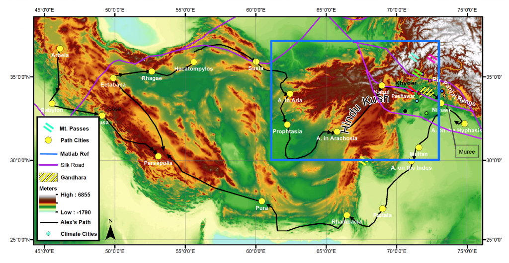
Around this time last fall, I was spending consistent hours in the basement of Fine Hall, gathering data from the Map Library and struggling with ArcGIS and Matlab to make sense of it. My goal? To explain the success of Gandhara, a little-known ancient civilization in northwest Pakistan.
I first learned about the region during an independent research project in my last semester of high school Latin. Gandhara started as an outpost for Alexander the Great’s generals but grew into an incredible region of diffusion between Greek and Indian cultures. Greek and Buddhist influences merged freely in philosophy, religion, and art, and not much research existed on the area.
Gandhara slipped from my mind until I resumed school in my first semester at Princeton. I was enrolled in FRS 187: Earth’s Environments and Ancient Civilizations, a geoscience seminar that traveled to Cyprus over fall break. In Cyprus, we used geophysics to examine unexcavated areas near a Princeton archeological dig house. As part of the course, we were responsible for writing three scientific papers explaining why a civilization succeeded or failed using topographical, mineral, and climate-based evidence. My mind turned naturally to Gandhara. I wanted to create one comprehensive paper examining its success, but I wasn’t sure that I could find sufficient evidence from three different angles.

First, I plotted Alexander’s route using topographic data and discovered (as I had hoped and expected) that it was smoother and lower than shorter alternatives. The next paper, however, forced me to start to utilize outside help to incorporate mineral research. Librarians in the little-known Map collection of Lewis Library helped me find detailed maps that covered Gandhara and then georeference them using ArcGIS.
For the final paper, I was at a loss. If I didn’t find supporting climate data, I would have to choose a different civilization and start over. I was wed to my subject, and dreaded the thought of switching to a different one—the kind of frustrating possibility we have all confronted before.
Countless emails to my professors, and lunchtime and regular office hours, and one long conversation about my paper on the plane trip back from Cyprus put me on a tentative path. After taking down several research options, including tree ring and ice core records, Pakistani climate data, and global climate models, I felt more confident that one of these possible paths would work. The ease with which I was able to obtain and use the various forms of data would determine which route my paper took.
I finally decided to examine Gandhara’s temperature and elevation compared to other cities in the area and to see how it suited the cultivation of wheat and barley, two major Ancient Greek crops. When my results proved that Gandhara indeed was closest suited to wheat and barley optimal temperature and rainfall, I felt an incredible thrill. I realized what scientists must feel when their experiments turn out the way they had hoped.
The finished product was the most fascinating research paper I have ever written, and I reaped huge benefits from seeking directed outside help. I used the support of Princeton librarians and professors, but also the frequent edits and suggestions of classmates, high school friends, and my Latin teacher. I created a story about how Gandhara formed and worked using trade information along the Silk Road, Alexander the Great’s personal goals, climate, minerals, and topography. Scant research exists on Gandhara, let alone on the scientific reasons why it thrived. It was empowering that as a freshman college student, I could break research boundaries and push my idea to fruition with ample support.

— Vidushi Sharma, Humanities Correspondent

